


Second edition of phenomnal Russian Atlas of the Oceans (Atlas Okeanov), dedicated to the Atlantic and Indian ocean, was a fundamental oceanographic work summarising modern knowledge about natural processes and phenomena occurring in the Atlantic and Indian ocean and the atmosphere extending above it. The increased interest in the ocean was driven by the gradual depletion of the mineral resources of the land and the need to search for new sources of industrial raw materials in ocean waters. The maps included in the atlas were compiled on the basis of domestic and foreign scientific data accumulated in the USSR, collected over the entire history of the study of the ocean, including during the International Geophysical Year (1957-1958), the Year of International Geophysical Cooperation (1959) and the International year of the quiet Sun (1964-1965). The use of the latest processing methods made it possible to analyse extensive hydrometeorological information and, based on the obtained characteristics, for the first time to build maps that reflect a number of processes and phenomena hidden from direct observation. This gave the atlas the features of an original scientific work.
This second volume of the Atlas of the Oceans consists of seven principal sections further divided into subsections:
Each chapter of the atlas is preceded by a text that briefly outlines the methodology underlying the construction of maps in this section, characterises the source materials, and, if necessary, indicates the scientific and practical significance of the elements presented on the maps.
In the first section of the atlas - History of ocean exploration maps of geographical discoveries and maps of the most important oceanographic expeditions operating in the Atlantic and Indian Oceans since the beginning of the 19th century until 1975. Separate maps show the Soviet oceanographic expeditions of 1957-1975, an outstanding contribution to the study of these oceans.
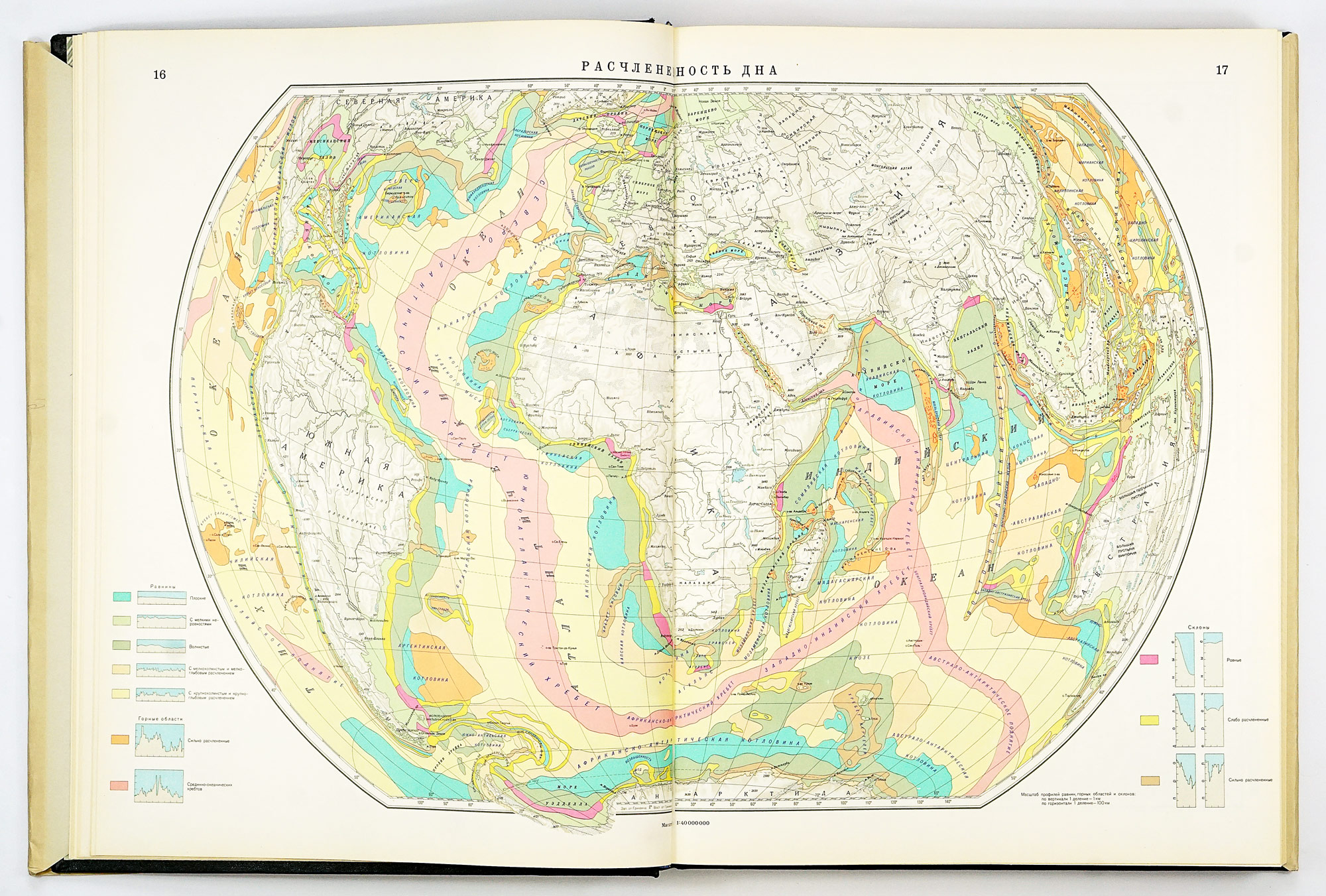
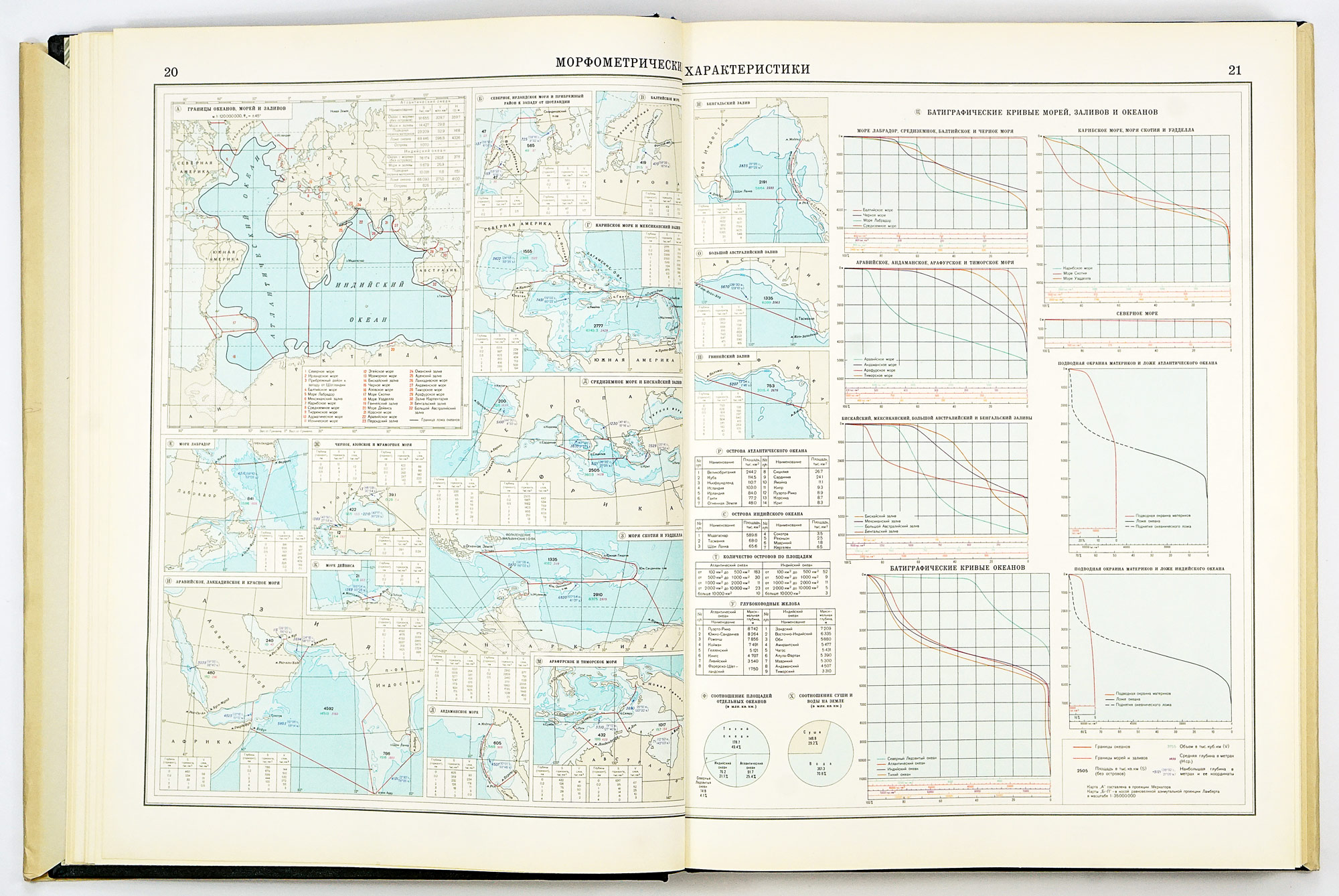
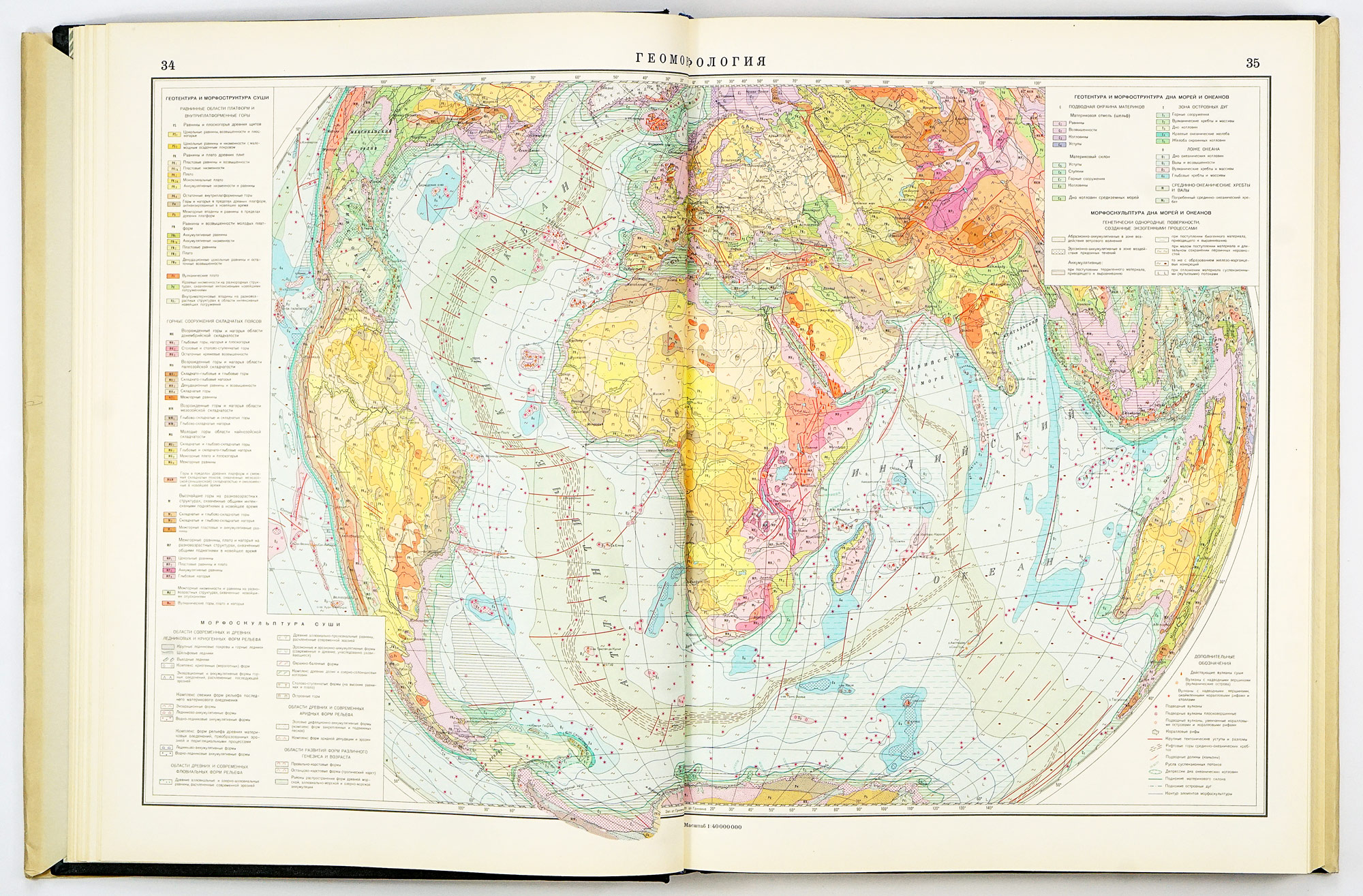
The Ocean Beds section covers topics related to the structure of the bottom and shores of the Atlantic and Indian Oceans and the reflective phenomena that cause their formation. As a result of studies carried out over the past 20-25 years, the great complexity of the bottom morphology and the distribution of bottom sediments in the Atlantic Indian Oceans has been established, and the connections between the processes of tectonic development of the bottom and the processes of deep development of the planet's body have also been studied.
The Climate chapter provides information on the thermal, water and circulation regimes of the atmosphere. The thermal regime is characterised by a series of heat balance maps and air temperature maps near the ocean surface and on isobaric surfaces of 500, 200, and 100 mb. For the same surfaces, wind regime maps are presented that reflect the circulation processes in the atmosphere. The water regime of the atmosphere is represented by maps of the distribution of precipitation, humidity, cloudiness, fog, and visibility. Synoptic processes over the oceans are characterised by maps of atmospheric fronts and types of atmospheric circulation. The section ends with an overview map of climatic zones and regions, which makes it possible to judge the main climatic patterns of the Atlantic and Indian Oceans.
In the Hydrochemistry section, all available information on the chemical regime of the waters of the Atlantic and Indian Oceans is summarised with sufficient completeness. Here, the spatial distribution of dissolved oxygen, the concentration of hydrogen ions, the distribution of alkalinity, and nutrients (phosphates, silicic acid) are presented. The combined consideration of these data allows obtain an indirect estimate of the biological productivity of the ocean. Maps of hydrogen ion concentration and alkalinity distribution not only characterise the living conditions of marine organisms, but also give an idea of the corrosive properties of water.
The Biogeography section contains a detailed description of organic life in the ocean - from the intensity of photosynthesis processes to the distribution of marine mammals. For the first time, important information is given about the values of primary production, the biomass of zooplankton and benthic fauna, and about benthic trophic areas. The distribution of fish of various species is presented in detail on several maps, and commercial-geographical complexes are identified.
The section Reference and navigation maps provides information about the Earth's magnetic field, astronomy, medical and geographical conditions, sea and air communications. Navigational-geographical charts contain general information on the geography of the Atlantic and Indian oceans and the land bordering them. The detail and reliability of the information presented on the maps of the atlas is even throughout the maps. In poorly studied areas are depicted by dotted isolines. In some areas, due to the lack of observations, the special load is not shown at all; such places on the maps are light blue in colour.
Each map has a legend with an explanation, applied conventional signs. Conventional signs common to all maps are also placed on a separate sheet, placed at the beginning of the atlas.
More than 2 dozens of Russian research institutes and state organisations participated on the development of this atlas, namely the USSR Fleet, the Main Directorate of Navigation and Oceanography of the USSR Ministry of Defense, the Naval and Military Medical Academy; research institutions of the USSR Academy of Sciences - the Botanical Institute, the Geographical Society of the USSR, the Geological Institute, the Main Astronomical (Pulkovo) Observatory, the Zoological Institute, the Institute of Geography, the Institute of Oceanology and many more.
Very good condition overall. Almost like new except very light toning of the dust jacket related to age. Comes in an original protective cardboard sleeve.
Interested in buying this atlas?
We can ship worldwide! Ask for a shipping quote or let us know if you are considering buying this atlas. We can send you more photos or answer any questions.
Interested in the price of this atlas?
Ask us in the form below. We can ship worldwide!
Want to get this atlas?Give us your e-mail and we will let you know, once the atlas becomes available again.


